Company plans to build massive floating city

 
This concept image shows what Freedom Ship International hopes to have their giant floating city look like. It would include all the amenities of a city on land, with the added bonus of sailing around the world.


This concept image shows what Freedom Ship International hopes to have their giant floating city look like. It would include all the amenities of a city on land, with the added bonus of sailing around the world.
 
This concept image shows what Freedom Ship International hopes to have their giant floating city look like. It would include all the amenities of a city on land, with the added bonus of sailing around the world.
 
This concept image shows what Freedom Ship International hopes to have their giant floating city look like. It would include all the amenities of a city on land, with the added bonus of sailing around the world.
 
This concept image shows what Freedom Ship International hopes to have their giant floating city look like. It would include all the amenities of a city on land, with the added bonus of sailing around the world.

. less

Water Bridge Over River — Magdeburg Water Bridge

 Magdeburg water bridge can rightfully claim to be a revolutionary breakthrough in bridge construction. The idea to build a navigable bridge that would connect Berlin with the ports on the Rhine River, originated in the distant 1870s. Prior to the creation of a specific project it came only in 1920.
  Construction was delayed during the First and Second World Wars. After Germany was divided at the beginning of the Cold War, the construction of the bridge was indefinitely postponed by the Government of the GDR. With the unification of Germany, his erection again become a major concern. Construction began in 1997 and was completed six years later, in October 2003. On the bridge were put huge amounts of money, more than half a billion euros. But the miracle built a bridge worth it.
 Spread over the Elbe, and began to operate a unique bridge-aqueduct, which connected the Elbe-Havel and Mittelland Canal. The total length of the bridge 918 meters, 690 meters from the above land, and the remaining 228 meters - above the water. Bridge builders started up the canal bridge. Channel width is equal to the canal on a bridge 34 meters and the depth of 4.25 meters, enough for unhindered passage of ships that "go" with the Berlin internal ports to ports in the industrial district on the Rhine.
 The bridge, though, and is used for the river crossing, but, in contrast to all existing bridges in the world, it does not move on land transport, and cross the river steamers and pedestrians only.


Algiers: Geography


Geography


Districts of Algiers


Notre Dame d'Afrique, built by European settlers in 1872


  • The Casbah (of Al Qasbah , “the Citadel”), Ier District of Algiers: called Al-Djazaïr Al Mahroussa
    (“Well Kept Algiers”), it is founded on the ruins of old Icosium. It is
    a small city which, built on a hill, goes down towards the sea, divided
    in two: the High city and the Low city. One finds there masonries and
    mosques of the 17th century; Ketchaoua mosque (built in 1794 by the Dey
    Baba Hassan) flanked by two minarets, mosque el Djedid (built in 1660,
    at the time of Turkish regency) with its large finished ovoid cupola
    points some and its four coupolettes, mosque El Kébir (oldest of the
    mosques, it was built by almoravide Youssef Ibn Tachfin
    and rebuilt later in 1794), mosque Ali Betchnin (Raïs, 1623), Dar
    Aziza, palate of Jénina. In the Kasbah, there are also labyrinths of
    lanes and houses that are very picturesque; and if one gets lost there,
    it is enough to go down again towards the sea to reposition oneself.

  • Bab El Oued : Literally the River's Gate,
    the popular district which extends from the Casbah beyond "the gate of
    the river". It is the capital's darling and best liked borough. Famous
    for its square with “the three clocks” and for its “market Triplet”, it
    is also a district of workshops and manufacturing plants.

  • Edge of sea : from 1840, the architects Pierre-August Guiauchain and Charles Frédéric Chassériau
    designed new buildings apart from the Kasbah, town hall, law courts,
    buildings, theatre, palace of the Governor, casino ... to form an
    elegant walk bordered by arcades which is the boulevard today Che Guevara (ex-boulevard of Republic).

  • Kouba (will daira of Hussein-dey):
    Kouba is an old village which was absorbed by the expansion of the town
    of Algiers. Of village, Kouba quickly developed under the French
    colonial era then continued growing due to formidable demographic
    expansion that Algiers knew after the independence of Algeria in 1962.
    It is today a district of Algiers which is largely made up of houses,
    villas and buildings not exceeding five stories.

  • El Harrach, a suburb of Algiers, is located about 10 kilometres (6 miles) to the east of the city.


  • The communes of Hydra, Ben Aknoun, El-Biar and Bouzareah
    form what the inhabitants of Algiers call the heights of Algiers. These
    communes shelter the majority of the foreign embassies of Algiers, of
    many ministries and university centers, which makes it one of the
    administrative and policy centers of the country.

  • The street Didouche Mourade is located in the 3rd district Of Algiers. It extends from the Grande Post office to the Heights of Algiers. It crosses in particular the place Audin , the Faculty of Algiers , The Crowned Heart and the park of Galland . It is bordered by smart stores and restaurants along most of its length. It is regarded as the heart of the capital.


 Astronaut view of Algiers


Climate


Algiers has a Mediterranean climate (Köppen climate classification Csa) with hot summers and mild winters. Its proximity to the Mediterranean Sea
aids in moderating the city's temperatures. As a result Algiers usually
does not see the extreme temperatures that are experienced in the
adjacent interior deserts. The climate of Algiers, like that of other
Mediterranean cities, features wet winters and dry summers. Algiers on
average receives roughly 600 millimetres (24 in) of rain per year, the
bulk of which is seen between October and April.


Snow is very rare; in 2012, the city received 10 centimetres (3.9 in), its first snowfall in eight years.


Climate data for Algiers
MonthJanFebMarAprMayJunJulAugSepOctNovDecYear
Record high °C (°F)25

(77)
30

(86)
28

(82)
33

(91)
32

(90)
40

(104)
42

(108)
47

(117)
40

(104)
38

(100)
32

(90)
30

(86)
47

(117)
Average high °C (°F)16.7

(62.1)
17.4

(63.3)
19.2

(66.6)
20.9

(69.6)
23.9

(75)
28.2

(82.8)
31.2

(88.2)
32.2

(90)
29.6

(85.3)
25.9

(78.6)
20.8

(69.4)
17.9

(64.2)
23.7

(74.7)
Daily mean °C (°F)11.2

(52.2)
11.9

(53.4)
12.8

(55)
14.7

(58.5)
17.7

(63.9)
21.3

(70.3)
24.6

(76.3)
25.2

(77.4)
23.2

(73.8)
19.4

(66.9)
15.2

(59.4)
12.1

(53.8)
17.4

(63.3)
Average low °C (°F)5.5

(41.9)
5.9

(42.6)
7.1

(44.8)
8.8

(47.8)
12.3

(54.1)
16.1

(61)
18.9

(66)
19.8

(67.6)
17.6

(63.7)
14.2

(57.6)
9.8

(49.6)
7.2

(45)
11.9

(53.4)
Record low °C (°F)−2

(28)
−1

(30)
−1

(30)
1

(34)
2

(36)
8

(46)
11

(52)
10

(50)
11

(52)
2

(36)
1

(34)
−2

(28)
−2

(28)
Rainfall mm (inches)81.4

(3.205)
72.7

(2.862)
55.0

(2.165)
58.4

(2.299)
41.9

(1.65)
8.5

(0.335)
4.5

(0.177)
8.2

(0.323)
28.3

(1.114)
58.8

(2.315)
89.6

(3.528)
91.0

(3.583)
598.3

(23.555)
Avg. rainy days (≥ 0.1 mm)11.410.69.79.17.32.51.52.55.38.611.112.191.7
 % humidity82807777757473717580808177
Mean monthly sunshine hours1491652022583193183503192372291651362,847
Source #1: World Meteorological Organization (UN),NOAA (1961-1990)
Source #2: Danish Meteorological Institute (sun and relative humidity),Weatherbase (record highs and lows)

Driver's lucky escape after tire smashes into windshield


Valentin Hristich escaped uninjured when the truck tire bounced onto his windshield outside Kiev

Toronto named worlds most youthful city, in a good way

The CN Tower is seen along the Toronto skyline from Centre Island.Congratulations, Toronto. According to a new index measuring major cities across the world, you are the most youthful.
And that youthful tag doesn't mean you are prone to tomfoolery (except, perhaps, at city hall) or need to be chaperoned at the grocery store, it means Toronto is the best place in the world to live, work and play.
The YouthfulCities Index named Toronto the "Youthful City of the Year 2014" for its diversity, its high levels of youth employment and digital access, among other features.  The city’s nightlife, music and arts scenes also played a positive factor.
Toronto beat out Berlin and New York, which placed second and third respectively.

The index, in its first year, is intended to quantify which cities are most attractive for people between the ages of 15 and 29. The thinking is that those cities that appeal to younger generations have an advantage at growing in the future.
"More than half of the world’s population is under 30 and more than half live in cities. It’s clear that cities will shape our world. And it is clear that the cities that will thrive and prosper are those that are able to attract and empower young people, YouthfulCities co-founder Robert Bernard said in a statement.
The Top 10 Youthful Cities are:
  1. Toronto
  2. Berlin
  3. New York City
  4. Dallas
  5. Paris
  6. Chicago
  7. London
  8. Los Angeles
  9. Tokyo
  10. Seoul
The rankings are based on youth-based indicators in 16 different categories, from civic participation and public transportation to fashion and music to entrepreneurship and youth employment.
Toronto finished in the top five in nine of the 16 categories, including diversity, youth employment, food and nightlife, music and film and public space. Toronto’s lowest rankings were 18th (out of 25) in safety and mental health and 23rd in civic participation.
Barnard also told the Toronto Star that transportation is a growing concern for Toronto's youth, as seen in a announced plan to increase public transit fares and a recent vote that almost killed the city's Bixi bike-share program.
"If city council had cancelled Bixi . . . there is a possibility that Toronto would not have won," he told the newspaper.
"The cost of transit disproportionately affects youth in the city. (Youth are) the ones who are disproportionately more likely to ride transit."


The index intends to become an annual ranking, gauging what young adults look for in a home and how cities stack up.
StatsCanada says that in 2011, about one-fifth (1.14 million) of the Greater Toronto Area's population of 5.58 million was between the ages of 15 and 29. The city's media age of 38.6 was lower than either Ontario (40.4) or Canada (40.6).
Attracting and retaining youth and young professionals has been a recipe for success in Toronto's past; no doubt it will continue in the future.

Million-dollar gold stash found in Indian aircraft toilet

Kolkata (AFP) - An Indian airplane cleaning crew stumbled across 24 gold bars worth over $1 million stashed in an aircraft toilet compartment, officials said Wednesday.
India, which rivals China as the world's biggest gold consumer, has witnessed a sharp rise in smuggling since import duties were hiked three times this year to dampen demand for the precious metal.
The plane, belonging to private carrier Jet Airways, was being cleaned at Kolkata airport Tuesday after a trip from the eastern city of Patna. Indian media reported the plane had been travelling from Bangkok.
"The cleaning staff of the airport were going though their routine duties and found two bags in the toilets of the plane," director of the airport B.P. Mishra told AFP.
The 24 one-kilogram gold bars "have not been claimed by anyone. No arrest has been made," senior customs official R.S. Meena said.
Meena estimated the value of the haul at about 70 million rupees, or $1.1 million.
Gold is hugely popular in India, especially during religious festivals and wedding seasons, and is the second-biggest contributor after oil to India's massive current account deficit -- the broadest measure of trade.
The government has been seeking to reduce gold demand and narrow its deficit by hiking bullion import duties.
Indians also buy gold in the form of jewellery, bars and coins as a hedge against inflation.
"This is the fifth (suspected gold smuggling) incident in the past one month," said B. P. Sharma, director of Kolkata's Netaji Subhash Chandra Bose International airport.
"Smuggling of gold through the airport has risen" as the hike in the import duty of gold has made the metal costlier, Sharma said.
Last month, intelligence officials recovered gold worth 95 million rupees from the toilet of a plane after it landed in the southern city of Chennai en route to New Delhi from Dubai.
Four Sri Lankan nationals were held on smuggling charges.
In August, customs officials seized smuggled gold worth 11 million rupees from a passenger travelling from Singapore to the Indian capital.
Thirty-one gold bars were found in specially-designed pockets in the suspect's trousers.
In Kolkata, a 28-year-old man flying to India from Bangkok was recently arrested with gold bars concealed in large torchlights, officials said.
In another incident, a man travelling to India from Dubai was caught in Kolkata while trying to smuggle five gold bars in his body, they added.

Amphibious Bus Dubai


Wonder Bus Tours is another Dubai city bus touring company, which was established in 2002 with a 44-seater bus manufactured in the United States. The air-conditioned bus is spacious with a large TV screen, an internal bathroom and refreshments are served during the tour of Dubai. The unique experience about riding this bus is that the tour of Dubai takes you around Dubai and also takes you on water, up and down the Dubai Creek. For safety measures, a life jacket is found under each seat and the bus has an automatic fire extinguishing system. The tour starts from the Bur Juman shopping center and takes a round of Shaikh Khalifa Road, Al Wasl Bridge, Wafi City Centre, Al Boom Restaurant before splashing into the Dubai Creek. The tour continues up and the down the Dubai creek before getting back on land, which then takes you past the Creek Park, Dubai Courts, Al Maktoum Bridge, Sheikha Maryam's Palace and then along Seef Road and Sheikh Khalifa Road before returning to BurJuman Centre. 
The tour lasts for 2 hours and operates twice a day (11am and 4pm), departing from the Bur Juman shopping mall. Passengers need to arrive atleast 20 minutes before departure and the tour costs Dhs. 115 (US$ 33) for adults and Dhs. 75 (US$ 22) for children between 3 and 12. Pick-up and drop-off services are available for people staying in Dubai for a fee of Dhs. 30 (US$ 8.50) per person.


Algiers: History


A Phoenician commercial outpost called Ikosim which later developed into a small Roman town called Icosium existed on what is now the marine quarter of the city. The rue de la Marine follows the lines of what used to be a Roman street. Roman cemeteries existed near Bab-el-Oued and Bab Azoun. The city was given Latin rights by Vespasian. The bishops of Icosium are mentioned as late as the 5th century.


Old Algiers in the 16th century, with the Spanish-built Peñón of Algiers in the forefront.


The present-day city was founded in 944 by Bologhine ibn Ziri, the founder of the Berber Zirid–Sanhaja dynasty. He had earlier (935) built his own house and a Sanhaja center at Ashir, just south of Algiers. Although his Zirid dynasty was overthrown by Roger II of Sicily in 1148, the Zirids had already lost control of Algiers to their cousins the Hammadids in 1014.[4] The city was wrested from the Hammadids by the Almohades in 1159, and in the 13th century came under the dominion of the Ziyanid sultans of Tlemcen. Nominally part of the sultanate of Tlemcen, Algiers had a large measure of independence under amirs of its own due to Oran being the chief seaport of the Ziyanids.


As early as 1302 the islet of Peñón in front of Algiers harbour had been occupied by Spaniards. Thereafter, a considerable amount of trade began to flow between Algiers and Spain. However, Algiers continued to be of comparatively little importance until after the expulsion of the Moors from Spain, many of whom sought asylum in the city. In 1510, following their occupation of Oran and other towns on the coast of Africa, the Spaniards fortified the islet of Peñon and imposed a levy intended to suppress corsair activity.[5]


Ottoman rule


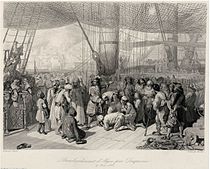
Abraham Duquesne delivering Christian captives in Algiers after the bombing in 1683.


In 1516, the amir of Algiers, Selim b. Teumi, invited the corsair brothers Aruj and Hayreddin Barbarossa to expel the Spaniards. Aruj came to Algiers, ordered the assassination of Selim, and seized the town and ousted the Spanish in the Capture of Algiers (1516). Hayreddin, succeeding Aruj after the latter was killed in battle against the Spaniards in the Fall of Tlemcen (1517), was the founder of the pashaluk, which subsequently became the beylik, of Algeria. Barbarossa lost Algiers in 1524 but regained it with the Capture of Algiers (1529), and then formally invited the Sultan Suleiman the Magnificent to accept sovereignty over the territory and to annex Algiers to the Ottoman Empire.


Algiers from this time became the chief seat of the Barbary pirates. In
October 1541 in the Algiers expedition, the King of Spain and Holy Roman
Emperor Charles V sought to capture the city, but a storm destroyed a
great number of his ships, and his army of some 30,000, chiefly made up
of Spaniards, was defeated by the Algerians under their Pasha, Hassan.


Historic map of Algiers by Piri Reis


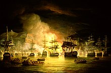
The bombardment of Algiers by Lord Exmouth, August 1816, painted by Thomas Luny


Ornate Ottoman cannon
found in Algiers on 8 October 1581 by Ca'fer el-Mu'allim. Length:
385 cm, cal:178 mm, weight: 2910 kg, stone projectile. Seized by France
during the invasion of Algiers in 1830. Musée de l'Armée, Paris.


Formally part of the Ottoman Empire but essentially free from Ottoman
control, starting in the 17th century Algiers turned to piracy and
ransoming. Due to its location on the periphery of both the Ottoman and
European economic spheres, and depending for its existence on a
Mediterranean that was increasingly controlled by European shipping,
backed by European navies, piracy became the primary economic activity.
Repeated attempts were made by various nations to subdue the pirates
that disturbed shipping in the western Mediterranean and engaged in
slave raids as far north as Iceland.[6] The United States fought two wars (the First and Second Barbary Wars) over Algiers' attacks on shipping.


The city under Ottoman control was enclosed by a wall on all sides,
including along the seafront. In this wall, five gates allowed access to
the city, with five roads from each gate dividing the city and meeting
in front of the Ketchaoua Mosque. In 1556, a citadel was constructed at
the highest point in the wall. A major road running north to south
divided the city in two: The upper city (al-Gabal, or 'the mountain')
which consisted of about fifty small quarters of Andalusian, Jewish, Moorish and Kabyle
communities, and the lower city (al-Wata, or 'the plains') which was
the administrative, military and commercial centre of the city, mostly
inhabited by Turkish dignitaries and other upper-class families.[7]


In August 1816, the city was bombarded by a British squadron under Lord Exmouth (a descendant of Thomas Pellew, taken in an Algerian slave raid in 1715[citation needed]), assisted by Dutch men-of-war, destroying the corsair fleet harboured in Algiers.


French rule


The history of Algiers from 1830 to 1962 is bound to the larger history of Algeria and its relationship to France. On July 4, 1830, under the pretext of an affront to the French consul—whom the dey had hit with a fly-whisk when the consul said the French government was not prepared to pay its large outstanding debts to two Algerian merchants—a French army under General de Bourmont attacked the city in the 1830 invasion of Algiers. The city capitulated the following day. Algiers became the capital of French Algeria.


Many Europeans settled in Algiers, and by the early 20th century they formed a majority of the city's population.[8] During the 1930s, the architect Le Corbusier drew up plans for a complete redesign of the colonial city. Le Corbusier was highly critical of the urban style of Algiers, describing the European district as "nothing but crumbling walls and devastated nature, the whole a sullied blot". He also criticised the difference in living standards he perceived between the European and African residents of the city, describing a situation in which "the 'civilised' live like rats in holes" whereas "the 'barbarians' live in solitude, in well-being".[9] However, these plans were ultimately ignored by the French administration.


During World War II, Algiers was the last city to be seized from the Germans by the Allies during Operation Torch.


City and harbour of Algiers, c. 1921


In 1962, after a bloody independence struggle in which hundreds of thousands (estimates range between 500,000 to 1,500,000) died (mostly Algerians but also French and Pieds-Noirs) during fighting between the French Army and the Algerian Front de Libération Nationale, Algeria gained its independence, with Algiers as its capital. Since then, despite losing its entire pied-noir population, the city has expanded massively. It now has about five million inhabitants, or 10 percent of Algeria's population—and its suburbs now cover most of the surrounding Mitidja plain.


Algerian War


Coat of arms of Algiers during French colonization


Algiers also played a pivotal role in the Algerian War (1954–1962), particularly during the Battle of Algiers when the 10th Parachute Division of the French Army, starting on January 7, 1957, and on the orders of then French Minister of Justice François Mitterrand (who authorized any means "to eliminate the insurrectionists"[citation needed]), led attacks against the Algerian fighters for independence. Algiers remains marked by this battle, which was characterized by merciless fighting between Algerian forces who, on the one hand, resorted to attacking the French civilians and pro-French Algerians, and the French Army who, on the other, carried out a bloody repression including the quasi-systematic use of torture on protesters of the colonial order. The demonstrations of May 13 during the crisis of 1958 provoked the fall of the Fourth Republic in France, as well as the return of General de Gaulle to power.


Independence


Algeria achieved independence on July 5, 1962. Run by the FLN that had secured independence, Algiers became a member of Non-Aligned Movement during the Cold War. In October 1988, one year before the fall of the Berlin Wall, Algiers was the site of demonstrations demanding the end of the single party system and the creation of a real democracy baptized the “Spring of Algiers”. The demonstrators were repressed by the authorities (more than 300 dead), but the movement constituted a turning point in the political history of modern Algeria. In 1989, a new constitution was adopted that put an end to the reign of the single party and saw the creation of more than fifty political parties, as well as official freedom of the press.


Crisis of the 1990s


The city became the theatre of many political demonstrations of all descriptions until 1992. In 1991, a political entity dominated by religious conservatives called the Islamic Salvation Front engaged in a political test of wills with the authorities. In the 1992 elections for the Algerian National Assembly, the Islamists garnered a large amount of support in the first round, helped by a massive abstention from disillusioned Algerian voters by the turn of events. Fearing an eventual win by the Islamists, the army cancelled the election process, setting off a civil war between the State and armed religious conservatives which would last for a decade.


On December 11, 2007, two car bombs exploded in Algiers. One bomb targeted two United Nations buildings and the other targeted a government building housing the Supreme Court. The death toll is at least 62, with over two hundred injured in the attacks.[10] However, only 26 remained hospitalized the following day.[11] As of 2008, it is speculated that the attack was carried out by the Al Qaida cell within the city.[12]


Indigenous terrorist groups have been actively operating in Algeria since around 2002.